Archive
07/14/2023 – Ephemeris – Finding Polaris and why it’s important
This is Bob Moler with Ephemeris for Friday, July 14th. Today the Sun will be up for 15 hours and 16 minutes, setting at 9:26, and it will rise tomorrow at 6:11. The Moon, 3 days before new, will rise at 3:46 tomorrow morning.
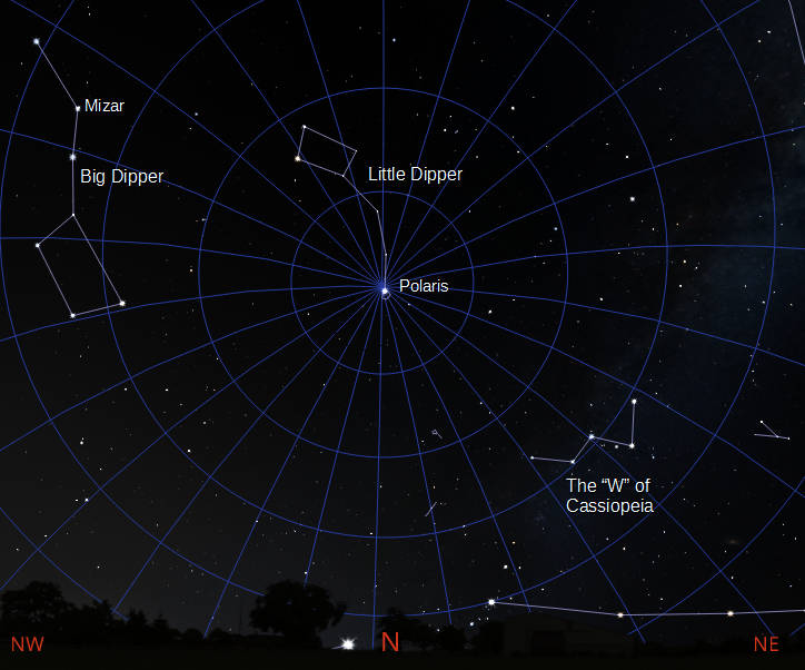
The most important star in the night sky, especially if you are lost, is Polaris, also called the North Star or Pole Star. Face Polaris and North is in front of you, East is to the right, west to the left and south will be behind you. To find Polaris, first find the Big Dipper. In the evening. This time of year, it’s hanging by its handle in the northwest, the direction that the sun set at. The two stars at the front of the bowl point to Polaris, which is to the right of it, now. Throughout the night, as the Earth rotates. Polaris will hold its position as all the other stars go around it in a counterclockwise direction. Polaris is at the end of the handle of the Little Dipper. That handle start’s vertically but curves to the left and is made of faint stars.
The astronomical event times given are for the Traverse City/Interlochen area of Michigan (EDT, UT –4 hours). They may be different for your location.
Addendum
10/06/2015 – Ephemeris – Deneb our home-town star
Ephemeris for Tuesday, October 6th. The Sun will rise at 7:46. It’ll be up for 11 hours and 27 minutes, setting at 7:14. The Moon, 2 days past last quarter, will rise at 2:36 tomorrow morning.
We, here in Traverse City, Michigan have a pretty unique relation to the bright star Deneb, as is any location near 45 degrees north latitude. Tonight at 9:23 Deneb will be three-quarters of a degree due north of the zenith. Due north means that it’s on our meridian, a line you may remember from your school days. For astronomers it passes from the north point on the horizon, through the overhead point or zenith to the south point on the horizon. Also due to our latitude Deneb is circumpolar, meaning that it doesn’t quite set on a clean northern horizon. Deneb and 56 other stars are used for celestial navigation, which is still taught in case the GPS system goes down due to solar or enemy action.
Times are for the Traverse City/Interlochen area of Michigan. They may be different for your location.
Addendum
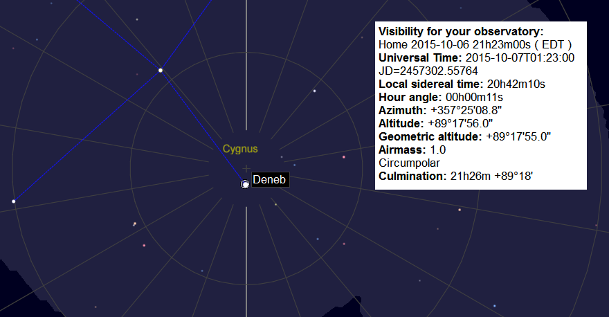
Deneb nearly at the zenith from Traverse City. Created using Cartes du Ciel.
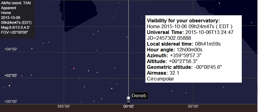
Deneb is close to the horizon due north. Created using Cartes du Ciel.
11/22/2012 – Ephemeris – Celestial navigation in the days of the Pilgrims
Ephemeris for Thanksgiving Day, Thursday, November 22nd. The sun will rise at 7:48. It’ll be up for 9 hours and 19 minutes, setting at 5:08. The moon, 2 days past first quarter, will set at 2:58 tomorrow morning.
Back in the days of the Pilgrims navigation was much less certain than it is today. At the mercy of the winds and weather, sailing took a lot of courage. Celestial navigation took the form of measuring the altitude of the pole star Polaris at night and the sun at noon. That and tossing a log overboard attached to a rope with knots at regular interval to gauge their speed and progress. That’s where we get the term knots as a measure of speed for nautical and aviation use. Today we have GPS to tell us where we are. However that is based on the position of not stars, but quasars, bright nuclei of distant galaxies, whose motions are currently too small to measure. Have a happy Thanksgiving.
Times are for the Traverse City/Interlochen area of Michigan. They may be different for your location.
Addendum

All sky map of quasar locations used as the celestial markers for the GPS system. Chart by David Bobolz, US Naval Observatory.
The chart above is from an article in the Telegraph.
